


Objectives
- The principal goal of our project was to identify riverine species, habitats, and ecosystems and species not adequately represented (i.e., gaps) in the matrix of conservation lands in Missouri.
- Provide spatially explicit data that could be used by natural resource professionals, legislators, and the public to make more informed decisions for prioritizing opportunities to fill these conservation gaps and to devise strategic approaches for developing effective long-term biodiversity conservation plans.
- As a pilot project for a national program, we also had the goal of developing a broadly applicable gap analysis methodology. We addressed this goal by ensuring that we utilized nationally standardized and available geospatial data wherever possible and also by devising a flexible conservation assessment methodology, which can accommodate the differences in data availability (e.g., biological) that exists among states across the United States.
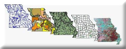
North America harbors an astounding proportion of the world’s freshwater species, but it is facing a freshwater biodiversity crisis. A first step to slowing the loss of biodiversity involves identifying gaps in existing efforts to conserve biodiversity and prioritizing opportunities to fill these gaps. The goal of the Missouri Aquatic GAP Project was to identify riverine ecosystems, habitats, and species not adequately represented (i.e., gaps) within existing conservation lands. Four principal GIS datasets were developed and used for this project: (1) a hierarchical riverine ecosystem classification, (2) predicted species distributions, (3) public ownership/stewardship, and (4) a human-threat index. Results of the gap analyses were not encouraging. Forty five, mostly rare, threatened, or endangered species are not represented in lands set aside for conserving biodiversity. Results also illustrated the fragmented nature of conservation lands, which are mainly situated in the uplands and fail to provide connectivity among riverine habitats. Furthermore, the results showed that many conservation lands are severely threatened by an array of human disturbances. Fortunately, the same data developed for this project can and have been used by resource planners and managers to fill existing gaps in our conservation efforts to develop more efficient and effective strategies for on-the-ground conservation efforts.
This project was completed in September 2005. A PDF of the final report and a peer-reviewed publication are available under “Project Files” on the project web page.
Project Files
- MoRAP Contact Information
To request a final report or other documents available for this project click the link. Please include the name of the project in your request.