
Objectives
- Create flexible databases on conservation opportunity areas for use by a variety of end users at different resolutions.
- Characterize the opportunity areas and areas at risk in order to rank them.
- Develop a set of databases that allows for flexible consideration of opportunities for natural resource management and conservation based on different needs/model applications.
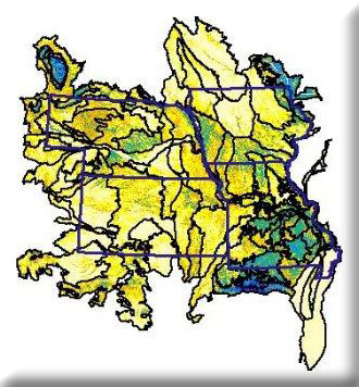
We calculated landscape metrics from the National Land Cover Database (NLCD) and digital elevation models (DEMs) in order to create a conservation opportunity area (OA) coverage for Iowa, Kansas, Missouri, and Nebraska. Conservation opportunity areas comprise 30.4% of the study area under a liberal model that counted patches closer to roads and patch edges, and 5.0% under a more conservative definition. We modeled landforms via neighborhood analysis of DEMs, and used landform representation as a conservation target to show how the OA coverage can be combined with other data to facilitate conservation planning in the St. Francois Knobs & Basins of southeastern Missouri. The delineation of OAs is only a first step in the iterative process of developing more detailed conservation plans. Currently, we are working on finer resolution site type models and seek to incorporate additional data on conservation targets and threats in order to refine our assessments and assign each 30-m pixel a value for overall significant to maintenance of biological sustainability on an ecoregion by ecoregion basis.
We identified and ranked conservation opportunity areas (OAs) across EPA Region 7. OAs are large patches of vegetation that represent the landscape of each ecological section. They are away from roads and away from landcover patch edges.