

Objectives
- Assemble Existing Data Layers into a GIS.
- Identify Priority Landscapes and Conservation Opportunity Areas.
- Provide Ongoing User Support for 12 Months.
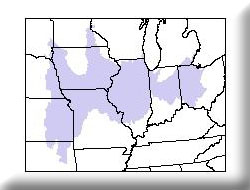
The Eastern Tallgrass Prairie Bird Conservation Region is one of the 67 BCR’s across North America identified by the four major bird initiatives and their conservation partners under the auspices of the North American Bird Conservation Initiative (NABCI). MoRAP will (A) create a turnkey geographic information system with appropriate primary data layers for evaluating conservation alternatives, and (B) analyze primary data layers in order to suggest landscape priorities and spatially explicit target conservation opportunity areas.
We created a turn-key GIS for the US FWS. This included the development of data that can be analyzed in a flexible way to identify priority landscapes and creation of an abiotic site type data layer and associated base data using digital elevation models. Data were provided via CD and we briefed US FWS staff on their utility.